Down The River
I like writing about rivers because I know it will go somewhere, even if I don’t tell much of a story. This is why so many novels go down rivers. Instead of building big machinery to progress the action, the author can sit back and blather as the river carries us forward. Heraclitus said you can’t step into the same river twice, but this is the observation of a land dweller. To someone traveling with the river, it is the world that changes. That’s why I go to rivers when the world feels stuck.
It was Sunday, May 31, 2020, one of the more intense days of rioting and protesting following George Floyd’s killing in Minneapolis on June 25, for you people in the future. A lot of friends of mine went downtown to the capitol and the police building. It seems like some people were mobs when they arrived and some were herded into mobs. They protested peacefully, broke some things, were beaten, shot, and arrested. I've been to a lot of protests and demonstrations and there is always someone on my side doing something I don't like. It was the same dudes at parties that got out of hand, at gym class in middle school, at ten year-old sleepovers. I figured that, after lending my body to the mass, I would have to do what the mob did and suffer what the mob suffered. It felt meaningless, so I went down the river instead.
Don't ask why it's called The Colorado, even though it begins and ends in Texas, even when there is already a Colorado River where one would expect it to be. Ok… Spanish explorers found the Brazos river, which they felt had a red appearance, and named it the Colorado, which means the color red. Then they found another river nearby, named it the Brazos, confused the two, then settled on the current arrangement, which has nothing to do with the state of Colorado. I can find no deeper meaning or narrative resonance in this story. Unlike rivers, names can be dead ends. I told you not to ask.
Above Longhorn Dam, the Colorado is a series of plateaus, lakes formed by dams and dotted with expensive houses. Coves lined with Cyprus offer wild pocket beaches on private land. Cliffs a hundred feet high undulate on the outside edge of river bends. There is a sense of scale and awe, but the river that did that to the land is gone. The water there now lies prostrate. It is so flacid and docile it seems doubtful it could run even if you took away the dams. Millionaire barbarians in glossy boats dominate the lake, bouncing life jacketed humans behind them. Speakers mounted to chrome frames are designed to inspire someone being pulled thirty feet from the boat with the engine at full throttle. The hull contains a chamber into which lake water is pumped to make the boat heavy so it produces a wave big enough to surf.
The boats’ wakes intersect as they pass, creating rhomboid waves that throw me off my board and the music’s intersecting doppler effects make me feel nauseous and psychotic as I scramble back on. Paddling here is like bicycling in the breakdown lane of an interstate highway.
One dam down, Ladybird Lake is motorless. It's a walled garden that runs through downtown with kayak rentals and the hike and bike trail along the edge of the nearly motionless water. It requires no planning. I've been exploring it for a decade, but these days I don't really explore so much as take refuge in its secrets and magic places; springs and cliffs I pretend no one else knows about, which I know by names my daughter gave them when she was a toddler. It's easiest to pretend at night, dipping my paddle in black glass between dark walls of trees and cliffs, when only the warm dinner lights of the fancy houses on the cliff interpose themselves between me and the moon.
From downtown, Longhorn dam is simply one edge of the lake, but if you stand on the dam, you see the feral river coming out the other side, shallow and fast. Why don't I go down that way? That way, the river has a mind of its own is why. Down there, the river would take me somewhere.
The next take out is where 973 goes over, nine miles down. Unlike the north end of town, which fades into corporate campuses and sprawl, the southeast lies as the farmers left it. Semi-wild, flat and soggy, dotted with cattle and stock ponds. The air is thick with oxygen and flatulence and mosquitos. It's cheap. My friend bought a few acres out in Dale where he goes to hang out and shoot his guns. A lot of people shoot their guns out there, he says on the weekends it sounds like world war three. The backroads are obscure. If you tell someone who lives in Austin that you live in Dale, they won’t know where that is unless they were here when the outskirts were of greater relative importance, before Austin became a mountain you could see in the distance. I've been here nearly twenty years and I never heard of Dale. Just say you're from south Austin, everyone knows about the airport and the F1 track. Somewhere in this miasma of hay and mesquite winds the Colorado. You can’t see it until you're driving across.
Driving down Riverside to the dam, I scan the battalion of homeless that were kicked out from under highway 360. There are more here than I have ever seen, it looks like a music festival happened in this median. I never would have thought it would be feasible for there to be this many homeless, with tents right downtown and shanty villages under freeways. But I'm not sure what Feasible means. I try to imagine what twice this many would look like and I can’t do it. I have this vague assumption about the homeless that, if it gets too bad, too dangerous, something will be done to fix it. There could never be, for example, a favela. A couple days ago I talked to neighbors who said they left Seattle in part because the homeless got to be “too much”.
A camping ban makes sense, in the same way outlawing poverty makes sense, or conducting a War on Drugs. My old boss, a corporate guru, would call this “dictating outcomes”, like saying the plan is to make 1 million in sales the first year. It is to be distinguished from an actual business plan. People see homeless and think the problem is that they are seeing homeless.
I have a plastic board with three short skags instead of the typical big one. It doesn't track great, but it gets over shallows and I don't have to worry about it getting punctured. I can carry it in one hand if I lean way over. I have to switch hands several times getting across the parking lot. I go down the bike path until I find a trail down a sloppy concrete embankment, an industrial magma flow with trees and brush growing in its pockets. It's tricky with the boat. At the waterline I put it down and feel like I might float up into the sky as I rub my shoulder. I take my time getting set, fighting the urge to jump on and sort it out in the river. A hispanic family is hanging out here, spending Sunday in the sun. The dad is casting, mom is wading, daughter watching something on the phone.
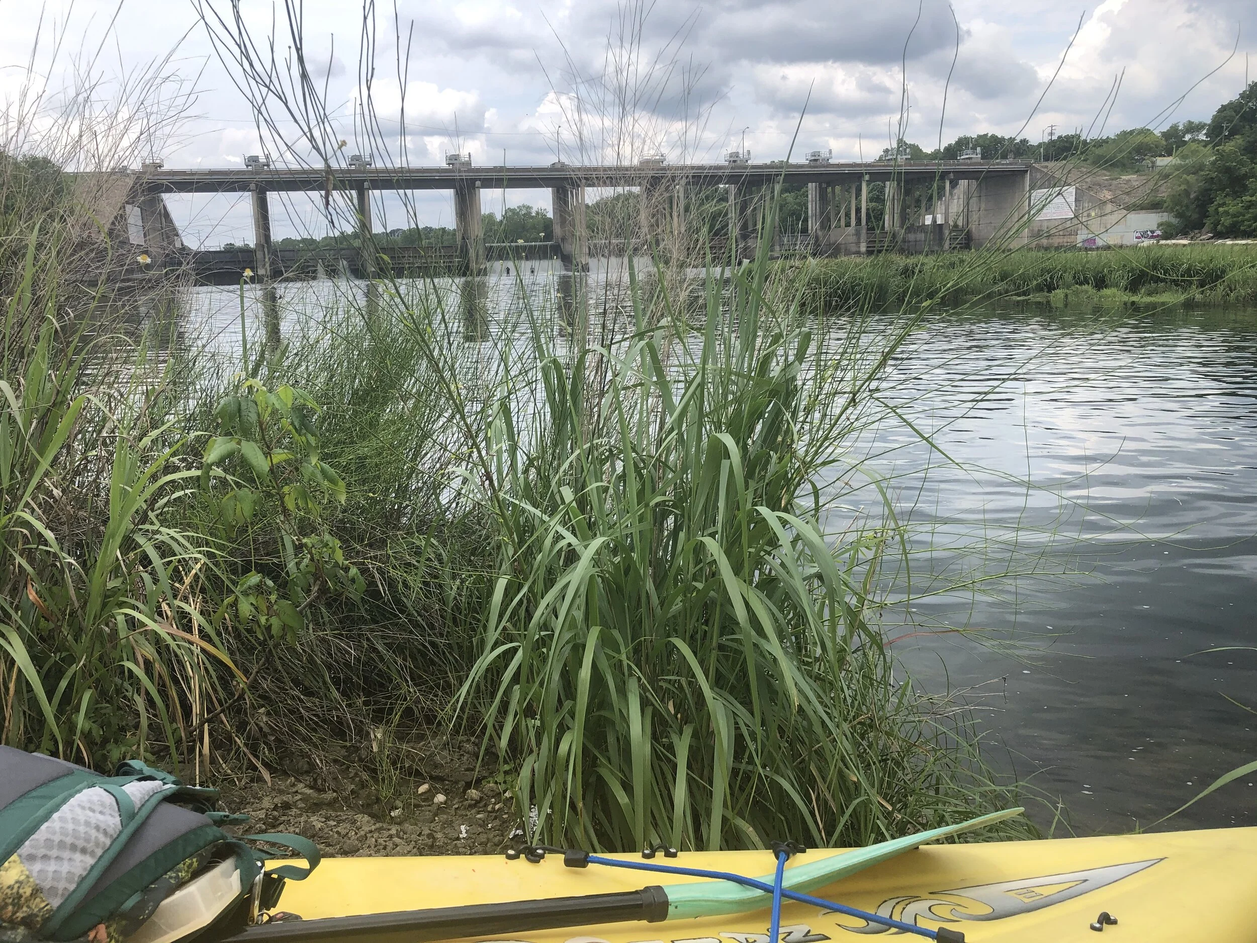
Longhorn Dam
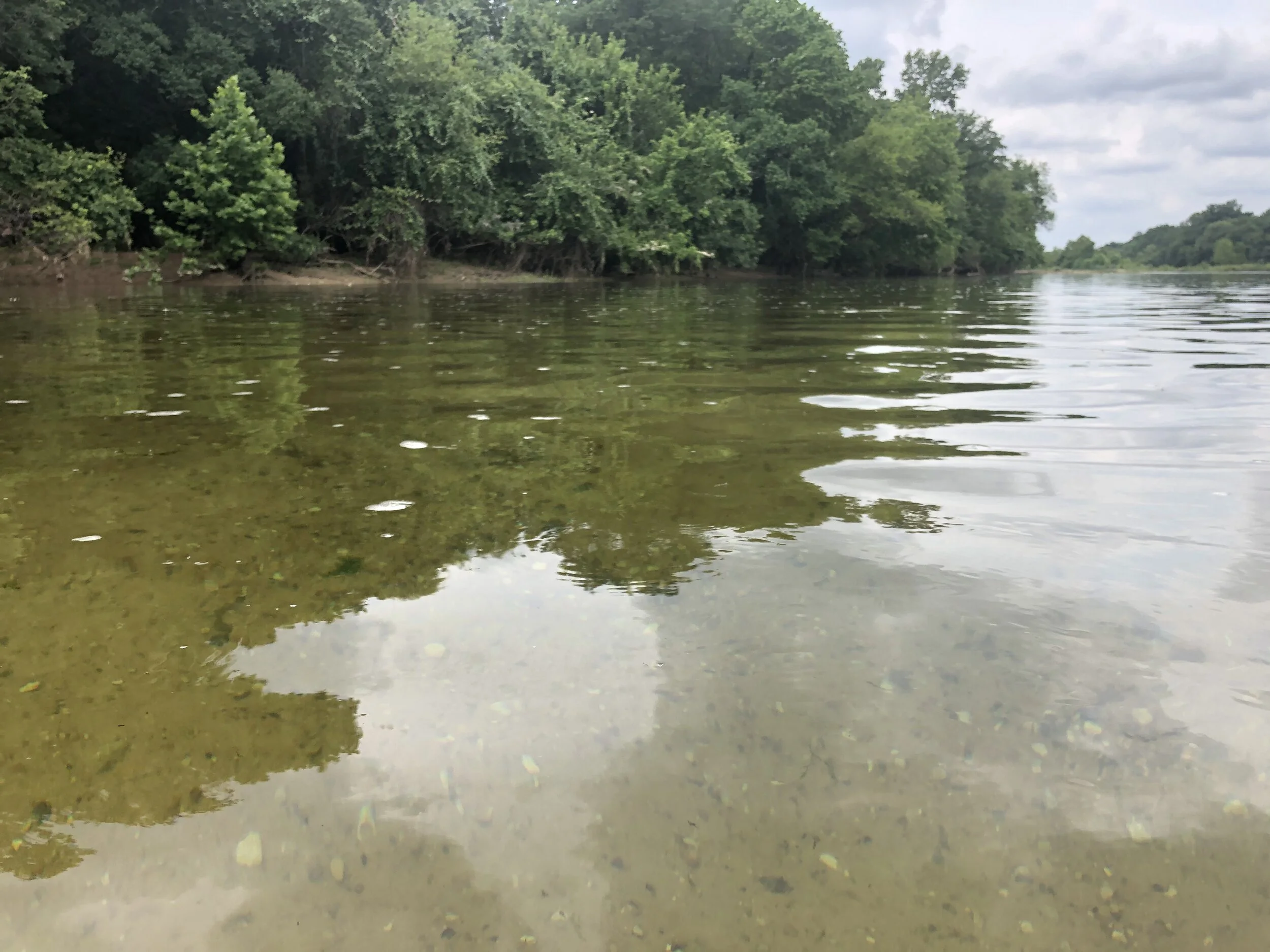
As it always does from the water, everything looks wilder. The water is higher than when I scoped this out a few weeks ago, when quarantine was new and the city felt abandoned. The surfaces of rocks and ledges are submerged all the way up to the dam where two fishermen walk the submerged ledge. The scattered islands of tall grass make the place feel like a japanese garden pond, unexpected just downstream of the city. I know the lake is there, behind the massive wall of mid century concrete, but it feels irrelevant. The Colorado is itself now, as if miles of lakes and scuba divers visiting abandoned towns had been different water. The river’s complications are visible now, there are no more secrets. Through three feet of water I see the texture of zebra mussels and rocks. Something like wild rice waves in the current with long shaggy hair. I float over a few inches to five feet that is clear and quick. Stripes of clay and limestone pass under me, larger clumps of reeds and islands line the sides. The backyards of all the addresses on the south side of Ceasar Chavez go by and a dozen secret places, riverside utopias hidden behind normal looking houses. A trail goes down the slope of trees and poison ivy to a few chairs, a grill, an upside down canoe.
I pass into the rural ghetto, a dirt pull out to a fishing spot with a wheeled office chair on its side. A tall sandy cliff behind a new housing development. A corner eddy is drilling the bottom down to clear darkness that tries to grab my boat as I pass and I watch a jellyfish chicken breast travel to the surface on some inverted vortex, fascia winging out like a slow flamenco dancer.
I am down inside the cut that is invisible from the flatlands of east austin. Red dirt cliffs 30 feet high alternate sides with gravel bars and trees. Another hispanic family waves at me from a bend, I can’t see a road or trail, it's as if they are part of the forest. I round a corner and see 183 cross high overhead in a tangled canopy of bridges and roads. Below me, thick pipes cross the bottom of a deep clear pool, mirroring the bridge. Some look derelict, like people don't clean up their pipes. The water flows around graffitied concrete footings with cars passing overhead. The river feels indoors here. I am below the most confusing road hairball in Austin. Perhaps when construction is over, it will be clear to me, but for the last several months, these roads have been redirected so often that Siri is reliably wrong in her calm robot patois. The red line on the map is repainted as a varicose vein that changes with each turn as I curse. Locals speed through this mess with no patience for people who have been gone for a week and don't know which re-directed frontage road will take them across the river and which into Webberville.
This would be a great place to park, if you can find it from the hellscape above. A fisherman stands on one of the concrete plateaus in jeans and a t-shirt. He looks like one of those guys who finds stolen moments, no one knows he’s here. He keeps a rod in his truck because he comes here instead of preparing for his next meeting or eating lunch with coworkers. Because of whatever it is that motivates people to fish. No netflix, no book. It's just standing on the piling and looking at the river, which does not tell any story that has a beginning or end. It wont grab your attention, but if you let your mind land on it like a dry fly, it will teeter there on surface tension, above the clear pool where you can see the fish and imagine what they are thinking.
I stop on a sand island just past 183 to reacquaint myself with my feet. It's legal to camp on these islands. A downside would be the bugs, which are thickest here between the river and the sky, and the possibility of flooding. You can check the weather before you go but if the river does swell just a little, you and your shit are headed to the Gulf long before they have to close any crossings.
My phone tells me that over the banks to my right are improbable ponds the size of several city blocks. They are scattered between gravel beds and fields in the Hornsby Bend oxbow. I sometimes see them from airplanes and each time it's a surprise. I never see any sign of them unless I see them from the sky or a map. They are bizarre shapes, like a toddler cut them out of construction paper and positioned them in the river bend. There are no roads that go to them, but looking closely at the map I see business names: Aaron Concrete Contractors, Capitol Aggregates, Marcelo’s Sand & Loam… they must be gravel operations, just like there once were downtown. After Longhorn went in, the industry just moved downstream. I wonder what those ponds are like, do they hold fish, turtles, snakes? Are they a wetland with reeds? They will remain mysterious to me this trip, as I am staying with the river.
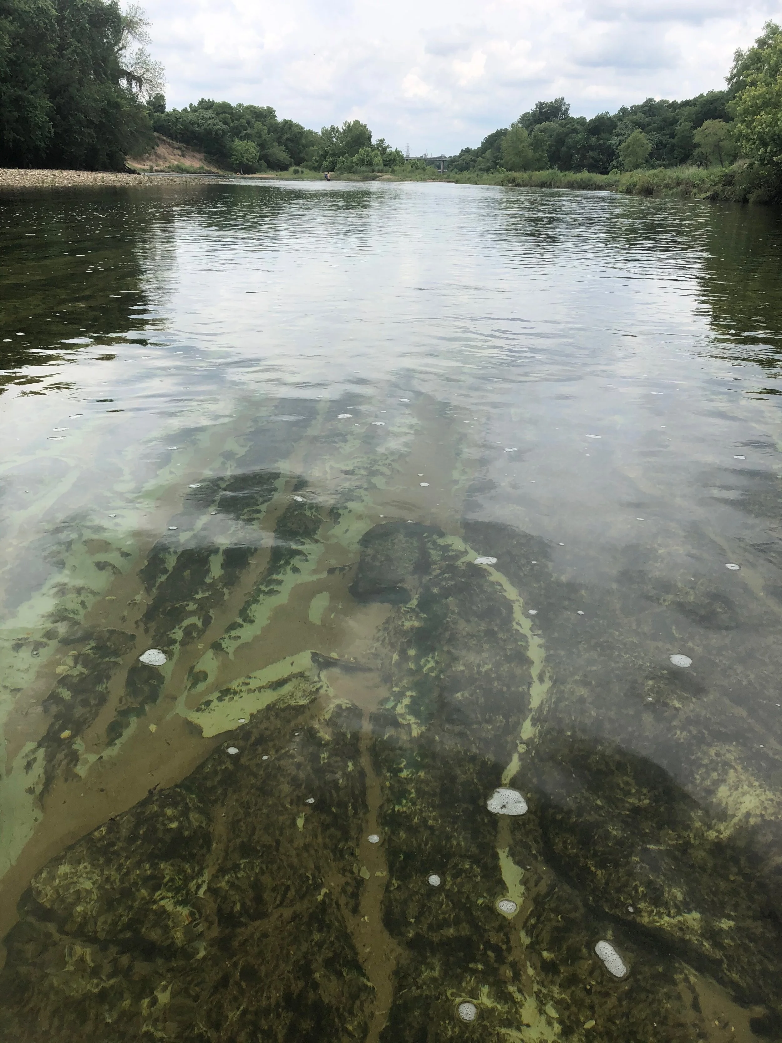
I turn into a channel that goes back up around an island. It leads to slow, dead ended water. Standing up, I can see into the water and I catch a glimpse of several torpedo sized carp before they accelerate in a way that seems impossible for their size, clouding the water. One pair seems odd, a typical grey followed by another that is deep, dark blue. Asian Grass Carp have been released into Lake Austin to control the weeds and hydrilla since 2002. To avoid creating yet another aggressively invasive species, they were sourced from fisheries that bred them to be triploid, meaning with triplicate chromosomes and incapable of reproduction. In 2014, Texas Parks and Wildlife cited the dubiously precise number of total carp at 48,369. No one is sure what their typical lifespan should be in this river, so it's hard to estimate how many of them are still here. TPWD halted stocking carp in 2016, when it became apparent they were degrading habitat for native fish by denuding the river bottom of plantlife. I'm no ichthyologist but this pair looked to me to be courting, which would be strange for neutered fish. Later I see a school of 5-6 inch fish in the shallows and suspect them of being juvenile carp.
It's nice there’s not so much hydrilla, but man, there are a lot of zebra mussels. The banks are lined with a solid wall of invasives: Chinaberry, Chinese Tallow, and Ligustrum, Elephant Ear, interrupted by muddy ramps where the feral hogs cross. Everything in view is deeply affected by human activity, yet, I'm all alone and haven't seen so much as a footprint for an hour. I feel like the first human to see this river.
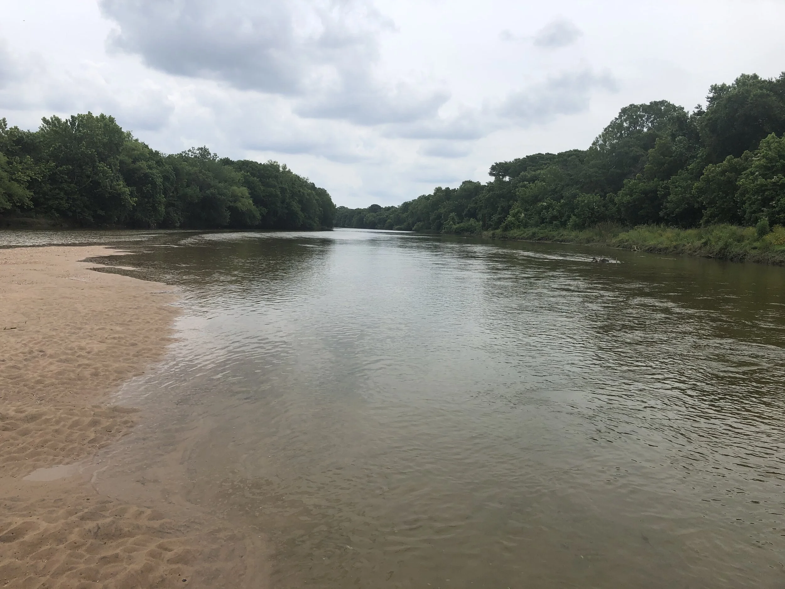
I've been paddling consistently. That and the current keeps me moving at a jog. The water is long and flat and deep now, except for the occasional bend over shallows where I have to stand up to see which side of an island to pass on. The water speeds up and wants to drag me through low branches.
On one placid stretch, I hear falls and see a perfectly flat horizon across the water. There is a softening in the middle and I consider pointing down it, but decide to tie up and take a look first. It's a low head dam, spilling down a three foot drop flat across the entire river. Low heads are more dangerous than they seem, and tend to catch boat shaped things in their hydraulics. I drag the boat over the rocks and put in below the dam.

The rest of the river would be monotonous if I was in a hurry. It's so slow and peaceful I shout and throw up my hands going through a gentle turn or riffle, which makes me feel drunk.
I pass solitary kayak fishermen, then bank fishermen. A fat man is fully passed out on a steep patch of damp dirt, his line in the water. I see the highway going over the river up ahead and hear Tejano music. Fishermen grow denser, but they are still solitary, these are the ones looking to get away from the noisy Sunday group. There is a party under the bridge. People are in the water on both sides, mostly kids, and my wife, who will always wait in the water if possible.
I’m lucky because this puts her in a good mood even though I am a full hour late. I get out and we wade together to the bank and maneuver the board between coolers and lawn chairs. The ground is large gravel, what rail workers call “ballast”. In between the rocks is dirt with trash, broken glass, and fish hooks packed into smooth mounds. I study it closely as I carry the boat to the car in bare feet.

FM973
Downstream lie more bends and land already permitted for a Tesla factory and mixed use development. The party under this bridge may have to go somewhere else as the neighborhood changes, but it’s portable. These people know how to use the grill that is left in the ashes. This place is a resource for travelers in the natural world, less like a rest stop than like the springs where the comanches watered their horses. The pulse I felt under Longhorn dam is gone and the river has become something else, carrying no memory of the city.
The next access point is in Webberville, 12 river miles down. It should be flat and calm and slow and wild. Onion and Gilleland Creeks will join the Colorado along a massive bend that will disorient me and make it difficult to track cardinal directions. Inside that bend is a massive lake, bigger than any of the previous gravel pits. It's too cold right now, and I am too happy to be on trails to do it. When it gets hot enough though, Austin will secrete me from the bottom of Longhorn dam like a gland that produces an oily rainbow tinted film of introspection on the surface of the Colorado.